The student crew has been working hard since our last post, and since tomorrow is our final day of fieldwork for the 2011 season, a photo update is below. We have learned a tremendous amount of new information over the course of the last 10 weeks, and even though we are still searching for clear indications of the overall size and configuration of both the presumed Spanish cavalry barracks and the overlapping residential structures under the clay cap just to the south (we may have as many as 5 or 6 now, some being explored by Lindsay Cochran and Sarah Bennett in the picture to the right), our progress this summer has been substantial, and we have far more data to work with in our interpretations than ever before. We look forward to our next summer's work at Mission Escambe, and are very grateful to Mr. Richard Marlow for his continued interest, support, and help in our project. With one more day of fieldwork, and additional testing scheduled for the area of the 19th-century mill below the mission site, keep tuned for more blog posts as news emerges regarding fieldwork and followup labwork related to the site.

Above, a crew shot of the 2011 Pensacola Colonial Frontiers field school on the first day of the dig in May; note the low water level in the Escambia River. Pictured are, left to right, Colin Bean, Danielle Dadiego, Norma Harris, Patty McMahon, Lindsey Cochran, Brady Swilley, Alesia Hoyle, Ashley Geisel, Michelle Pigott, Nick Simpson, Rachael Mead, Ralph Hosch, Joe Stevenson, Phillip Mayhair, Jonathan Harpster, Sarah Bennett, John Hueffed, Marie Burrows. Not pictured: Katie Brewer, John Worth.

Above, a final crew shot for the 2011 Pensacola Colonial Frontiers field school; note the high water level in the Escambia River on the same dock. Pictured are, left to right, Marie Burrows, Katie Brewer, Norma Harris, John Worth, Danielle Dadiego, Jonathan Harpster, Ralph Hosch, Lindsey Cochran, Joe Stevenson, Michelle Pigott, Phillip Mayhair, Patty McMahon, Sarah Bennett, Brady Swilley, Colin Bean, Ashley Geisel, Nick Simpson, Rachael Mead, Alesia Hoyle. Not pictured: John Hueffed.

Ralph Hosch bisecting a deep prehistoric post feature below the 19th-century board drain feature visible in the profile wall above.

Alesia Hoyle shading the profile of a bisected feature she is mapping.

Above, a portion of the foot-ring base of a Mexican majolica bowl.

Rachael Mead carefully draws a scaled plan view map of an excavation unit in which animal burrows had previously jumbled mission-era deposits.

Above, a sherd of prehistoric Deptford Check Stamped pottery, associated with the occupation of the Escambe site some 2,200 years ago.

Colin Bean hammers a 1/2 inch soil coring device into the base of a deep feature within a deep excavation unit, hoping to learn more about the underlying stratigraphy of the terrace on which Mission Escambe sits.

A profile view showing the natural soil stratigraphy at the site, extending from surface humus and an underlying 18th-century midden through grayish yellow sandy clay, grading to more orange hues below. Note the archetypical postmold cross-cutting this natural soil profile on the right side.

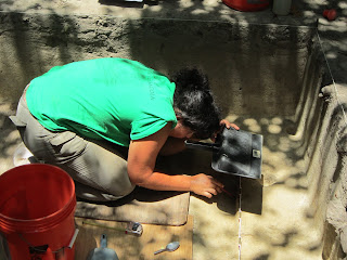
Brady Swilley photo-cleaning the floor of the excavation unit with the square well dating to the late 19th-century sawmill period; note the builder's trench encircling the central dark fill within the well itself.

Michelle Pigott and Jonathan Harpster map the profiles of a long slot trench excavated in hopes of discovering a northern wall for the presumed cavalry barracks (no trench was ultimately found here).

Danielle Dadiego explains our excavations to members of the Molino Historical Society during their visit to Mission Escambe; also pictured are Jonathan Harpster and Michelle Pigott in the unit.

Above, members of the Colonial Frontiers field school listening to Sarah Hooker explain the stratigraphy of an excavation unit on the site of the UWF Campus Survey field school during our visit there; also pictured are Colin Bean, Lindsey Cochran, Jennifer Melcher, and John Hueffed. Thanks to Dr. Ramie Gougeon, April Holmes, and the supervisors and crew on the Campus Survey for their hospitality in welcoming us to their dig site!
 As of Friday morning, the last official day of the 2011 field school, all but two excavation blocks at Mission Escambe had already been backfilled by morning (see picture to right), so we concentrated most of our students in the southernmost area, where several remaining feature and unit transects had to be excavated before documenting the final profiles and plan view maps of each unit, ultimately to be followed by backfilling. Nevertheless, despite our careful plans to finish excavations with a long day on Friday, the skies opened up mid-morning and continued to pour until we finally gave in and moved to the gazebo at the Molino boat ramp for an early lunch.


