As radar views confirmed the continuous onslaught of rain, however, the crew took a celebratory swim in the Escambia River before packing up for the last day, realizing that the staff and student supervisors, along with a handful of student volunteers, will have to return for some additional work next week. Our final bedraggled crew shot, taken between episodes of spontaneous puddle jumping, appears below.
Saturday, July 23, 2011
Last official day of field school
As radar views confirmed the continuous onslaught of rain, however, the crew took a celebratory swim in the Escambia River before packing up for the last day, realizing that the staff and student supervisors, along with a handful of student volunteers, will have to return for some additional work next week. Our final bedraggled crew shot, taken between episodes of spontaneous puddle jumping, appears below.
Thursday, July 21, 2011
Wrapping up the 2011 field season
Above, a crew shot of the 2011 Pensacola Colonial Frontiers field school on the first day of the dig in May; note the low water level in the Escambia River. Pictured are, left to right, Colin Bean, Danielle Dadiego, Norma Harris, Patty McMahon, Lindsey Cochran, Brady Swilley, Alesia Hoyle, Ashley Geisel, Michelle Pigott, Nick Simpson, Rachael Mead, Ralph Hosch, Joe Stevenson, Phillip Mayhair, Jonathan Harpster, Sarah Bennett, John Hueffed, Marie Burrows. Not pictured: Katie Brewer, John Worth.
Above, a final crew shot for the 2011 Pensacola Colonial Frontiers field school; note the high water level in the Escambia River on the same dock. Pictured are, left to right, Marie Burrows, Katie Brewer, Norma Harris, John Worth, Danielle Dadiego, Jonathan Harpster, Ralph Hosch, Lindsey Cochran, Joe Stevenson, Michelle Pigott, Phillip Mayhair, Patty McMahon, Sarah Bennett, Brady Swilley, Colin Bean, Ashley Geisel, Nick Simpson, Rachael Mead, Alesia Hoyle. Not pictured: John Hueffed.
Ralph Hosch bisecting a deep prehistoric post feature below the 19th-century board drain feature visible in the profile wall above.
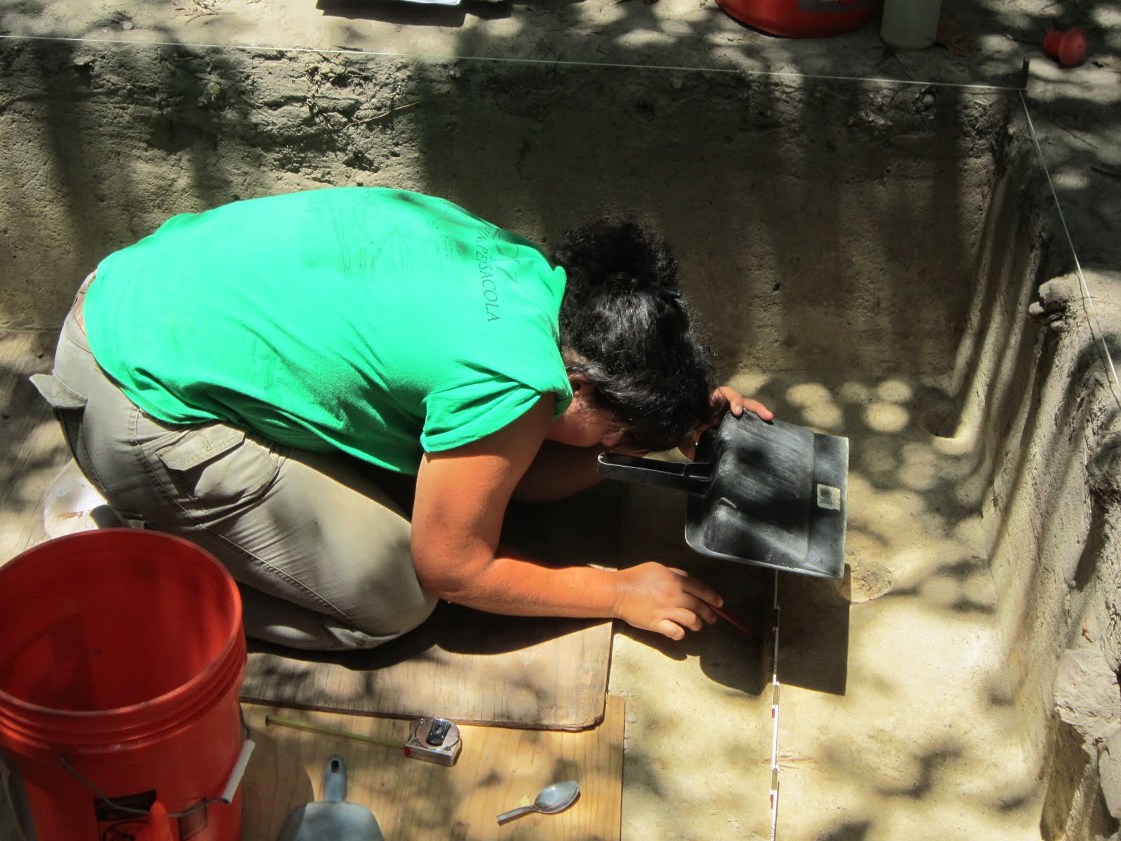
Alesia Hoyle shading the profile of a bisected feature she is mapping.
Above, a portion of the foot-ring base of a Mexican majolica bowl.
Rachael Mead carefully draws a scaled plan view map of an excavation unit in which animal burrows had previously jumbled mission-era deposits.
Above, a sherd of prehistoric Deptford Check Stamped pottery, associated with the occupation of the Escambe site some 2,200 years ago.
Colin Bean hammers a 1/2 inch soil coring device into the base of a deep feature within a deep excavation unit, hoping to learn more about the underlying stratigraphy of the terrace on which Mission Escambe sits.
A profile view showing the natural soil stratigraphy at the site, extending from surface humus and an underlying 18th-century midden through grayish yellow sandy clay, grading to more orange hues below. Note the archetypical postmold cross-cutting this natural soil profile on the right side.
Brady Swilley photo-cleaning the floor of the excavation unit with the square well dating to the late 19th-century sawmill period; note the builder's trench encircling the central dark fill within the well itself.
Michelle Pigott and Jonathan Harpster map the profiles of a long slot trench excavated in hopes of discovering a northern wall for the presumed cavalry barracks (no trench was ultimately found here).
Danielle Dadiego explains our excavations to members of the Molino Historical Society during their visit to Mission Escambe; also pictured are Jonathan Harpster and Michelle Pigott in the unit.
Above, members of the Colonial Frontiers field school listening to Sarah Hooker explain the stratigraphy of an excavation unit on the site of the UWF Campus Survey field school during our visit there; also pictured are Colin Bean, Lindsey Cochran, Jennifer Melcher, and John Hueffed. Thanks to Dr. Ramie Gougeon, April Holmes, and the supervisors and crew on the Campus Survey for their hospitality in welcoming us to their dig site!
Saturday, July 9, 2011
Sights and sounds of the Molino dig
A new YouTube video has been uploaded, with a compilation of some of the sights and sounds of ongoing archaeological work at Mission Escambe. Only two weeks of fieldwork remain, and more blog posts will follow.
Saturday, July 2, 2011
Seven weeks down, three to go
Below are more images of the past week of fieldwork.
Above, Lindsey Cochran balances high above the 2-meter-long slot trench using a ladder and tree branch (with Danielle Dadiego steadying the ladder) to take a full plan view photo of the unit at this level.
Ralph Hosch demonstrates flat-shoveling as participants in a statewide teacher workshop listen to Lindsey Cochran explaining the excavations in Area C.
Nick Simpson and Phillip Mayhair demonstrate "close quarters" archaeology as they excavate simultaneously in the bottom of a 1.0 x 1.5 meter excavation unit.
Alesia Hoyle, above, demonstrates another example of the awkward poses sometimes required during archaeological excavation in deep units.
Colin Bean with a precision GPS (Global Positioning System) unit designed to tie in the established site grid at Mission Escambe to global UTM (Universal Transverse Mercator) coordinates in order to facilitate the use of GIS (Geographic Mapping Systems) software for mapping purposes. Yes, that's a lot of acronyms!
Ashley Geisel shows off a wrought iron nail with preserved wood that looks remarkably similar to the crucifix we have all been imagining finding one day at the mission.
Michelle Pigott shows another large nail with well-preserved remnants of the wood in which it was originally embedded.
Thursday, June 30, 2011
Pilgrimage to Apalachee
Today the students and staff of the Colonial Frontiers field school were joined by the members of two other UWF field schools (Maritime and UWF Campus) in a caravan leading to Mission San Luis, the reconstructed 17th-century capital of the Apalachee mission province in present-day Tallahassee, Florida. The trip was especially meaningful, since some of the Apalachee inhabitants of Mission Escambe in Molino (or their parents or grandparents) may well have been born in Mission San Luis before its destruction in 1704. We were also intrigued to see the configuration and construction details of buildings reconstructed for the public at the site, and to learn more about the archaeological findings that have led to the remarkable reconstructions and new museum facility. We were led on a fascinating tour of the site by archaeologist Heidi Edgar, who appears in several of the photos below along with the students. Today's blog post will simply be a photo essay on our trip.
Group photo showing the nearly 50 UWF students and staff in front of the huge mission church at San Luis.
Students approaching the reconstructed Apalachee council house.
Entering the narrow door to the council house.
Students learning about the archaeology that led to the reconstruction in which they are standing.
Another view showing the gargantuan size of the council house.
Students having a closer look at the reconstructed Spanish family dwelling on the edge of the town plaza, recently re-roofed with plank shingles instead of thatch.
A view of the reconstructed Spanish fort, built near the end of the mission's existence as defense against increasing English/Creek hostilities which eventually led to the destruction and abandonment of the mission.
The entrance to the "casa fuerte" within the stockade and moat.
Students perusing the interior of the mission church (and probably wondering if we will eventually be able to identify the presumably much smaller church at Mission Escambe).
A view inside the archaeological lab at Mission San Luis, where students were treated to a look at a diverse array of remarkable artifacts from the Apalachee/Spanish mission community.
Thursday, June 23, 2011
Rain days, labwork, and more progress
Bags of artifacts collected from the sifting screens in the field were carefully sorted by size, and then by material (stone, ceramics, iron, glass, etc.),
We did have several good days of fieldwork this week however, as the pictures below will illustrate:
Above, Ralph Hosch carefully draws a profile map of the north wall of a unit that has just been excavated, so that the next unit to the north can be excavated next, in part using this profile drawing as a guide to which soil layers may be encountered next.
Using her well-equipped excavation kit to the right, Danielle Dadiego clears exposed ceramics and charcoal at the surface of a newly-identified feature just below the 19th-century brick-lined trench previously excavated here.
Above, a sherds of colorful Mexican-made majolica, probably Abó Polychrome, next to another sherd that has lost its surface glaze.
The uppermost deposits in most excavation units at Mission Escambe contain debris from the late 19th-century sawmill which occupied the lowlands below the terrace bluff, including the iron spikes and coal pictured above.
Saving the shade-giving trees at the site from the need to clear for mapping using the total station sometimes involves extreme measures in order to bend the trees out of the way, as Lindsey Cochran and Danielle Dadiego demonstrate above.
Saturday, June 18, 2011
Half way through
This colono ware sherd was recovered from deep within the posthole pictured above, and was almost as wide as the posthole itself. Well over a dozen other good-sized sherds have been recovered from this posthole, which obviously served as an impromptu dump for trash.
More pictures of recent work at Mission Escambe are presented below (along with a link to a video).
Above, Colin Bean practices high-tech archaeological fieldwork, excavating in front of a laptop computer!
Students Ashley Geisel and John Hueffed continue work exploring the eastern end of the long wall-trench structure that we have been following since 2009, now including a very large subsurface disturbance that either borders the end of the wall or truncates it to the east.
Danielle Dadiego explains the yellow clay cap layer to retired National Park Service archaeologist Bennie Keel, while Rachael Mead flat-shovels through the tough clay.
And finally, linked here is a YouTube video of our "quick-exit" strategy for impending downpours...pile all the students into Norma Harris' truck for a quick ride to the parking area!
Subscribe to:
Posts (Atom)